On 9 October 1963, in the offices of the Italian electricity board in Venice, Alberico Biadene wrote a letter to the engineer in charge of the Vajont dam, Mario Pancini, who was on holiday and about to leave for Wiesbaden. The letter told him to come back. “Returning to the Vajont,” Biadene wrote, “I will tell you that in these days the velocities of translation of the landslide have decidedly increased. Yesterday morning they were, for some points, 20 centimetres in twenty-four hours, and this both low down and high up.” He listed what he had seen on the mountain the day before: the cracks in the ground, the dips in the road, “the evident leaning of the trees on the slope above the Pozza, the opening of the great fissure that bounds the landslide zone, the moving of points even towards the Pineda that until now had stayed still”, and he said that all of it “makes one think the worst”. Then he gave the number that the whole affair had come to rest on. “Meanwhile the reservoir is falling a metre a day and this morning should be at level 700. I think of reaching level 695, always with the aim of creating a band of safety for the waves.”
Level 700 was 700 metres above the sea, and it had come from a model. Fifteen months earlier a professor of hydraulics at Padua had written, after twenty-two runs on a 1:200 copy of the reservoir in which a landslide was played by gravel, that the level of 700 metres “may be considered of absolute safety in respect even of the most catastrophic foreseeable landslide event”. The letter was dated the 9th because Biadene had been at the dam until the afternoon of the 8th. At thirty-nine minutes past ten that night, with the water at 700.4 metres, about 270 million cubic metres of Monte Toc left the mountain and crossed the reservoir in less than a minute.
Who ran it
The Vajont was a project of the Società Adriatica di Elettricità, SADE, the electricity company of Venice, which had been planning a dam in the gorge of the Vajont torrent, above Longarone in the Piave valley, since the 1920s. The designer was Carlo Semenza, head of SADE’s hydroelectric construction service. Below him were Biadene, director of hydraulic construction, and Pancini, director of works at the Vajont. SADE’s geologist was Giorgio Dal Piaz, a professor at Padua who had examined the valley in 1928 and found nothing to stop a reservoir there, and who was, the parliamentary commission wrote later, “considered one of the greatest experts in the geology of the eastern Alps and Pre-Alps”. The company’s geophysicist was Pietro Caloi, director of the National Institute of Geophysics in Rome, who put a seismograph in the dam’s control cabin at the end of 1959. For the mechanics of rock it hired Leopold Müller of Salzburg, “considered one of the greatest and rarest specialists in rock mechanics”. For the geology of the reservoir banks, in the summer of 1959, Carlo Semenza sent his son Edoardo, a young geologist, with a colleague named Franco Giudici. For the waves, in 1961, he went to Augusto Ghetti, director of the Institute of Hydraulics of the University of Padua, whose model centre stood at SADE’s power station at Nove, near Vittorio Veneto.
The state’s side was the Ministry of Public Works in Rome: its Dam Service under Francesco Sensidoni, the Fourth Section of the Superior Council of Public Works under Curzio Batini and later Pietro Frosini, and the provincial engineering office, the Genio Civile of Belluno. A testing commission followed the work as it went up; its geologist was Francesco Penta of Rome, “considered one of the greatest specialists in landslides”. A government assistant engineer at the dam, in 1963 Mario Bertolissi, was told from January 1961 to follow the landslide as well as the concrete. In December 1962 Italy nationalised its electricity. SADE’s plants passed to the new board, ENEL, with their staff, and on the night of 9 October the dam belonged to ENEL and was run by the same men.
On the mountain lived the people of Erto and Casso, two villages on the north side of the valley opposite the slope that moved, and below the dam, in the Piave valley, the town of Longarone. From 1959 a correspondent of the Communist daily L’Unità, Tina Merlin, born in the province of Belluno in 1926, wrote about them.
What they were trying to find out
There were two hypotheses, and they were tested on the same water.
The first came out of the autumn of 1960. The reservoir had begun to fill in February of that year, and by October it stood at about 650 metres. In that month a crack more than two kilometres long opened across the slope of Monte Toc above the lake, and on 4 November some 700,000 cubic metres of the slope’s toe fell into the water in less than half an hour, raising a wave two metres high. Müller came, with Edoardo Semenza, and on 15 and 16 November they met at the dam. His report of 3 February 1961, which the commission quotes, said that the mass moving above the lake was about 200 million cubic metres, in two bodies on either side of the Massalezza stream, the lower part of the western one moving like a glacier, faster at the surface than at depth. Nothing could stop it. What could be done, he wrote, was to control it: a slow, controlled lowering of the lake had already been decided on 16 November, “and after a week the first successes showed themselves”. He concluded that “in future it will be possible to establish a relation between the level of the lake, the precipitation and the velocity of sliding, and so to have the possibility of regulating the velocity”. That was the hypothesis: that the mountain’s speed could be governed by the water, and that if it was let down slowly against the lake it would build itself a foot and come to rest. Everyone who mattered accepted it. Edoardo Semenza wrote afterwards that “all of the experts studying the problem, including those of the Testing Commission, agreed upon a program of prudent experimental impoundings of the reservoir in the hope of achieving a more complete understanding of the nature and size of the sliding mass”. The Italian word was invaso sperimentale, an experimental filling, and that is what every authorisation from Rome called it for the next two and a half years.
The second hypothesis was about the wave. If part of the mass fell, it would throw water. A note of the meeting of 16 November 1960 records Biadene saying that “since the first concern must be to guarantee the safety of the people who live in the valley, it is necessary to lower the level of the reservoir so that, if a landslide of great size occurs which creates waves, these absolutely cannot reach the inhabited zone”, and that “as regards these waves, at the University of Padua the possibility is being studied of analysing on a model both the landslide movement and the wave motions it causes”. Edoardo Semenza says the idea was his father’s. The claim to be tested was that a physical model could tell what wave a given slide would make at a given water level, and so where the water should be held.
The two hypotheses fitted together. The model would give a safe level. Below it, the mountain could be let into the lake by degrees, with the water as the control, and watched.
What they built
The dam was finished in September 1960. Carlo Semenza described it that year in a local review: a double-curvature arch, “the highest double-curvature dam in the world”, 262 metres high, 350,000 cubic metres of concrete, 190 metres along the crest, 22 metres thick at the base and 3.40 at the top, a shell that carried the water’s push into the rock of the two sides. Its reservoir held 150 million cubic metres. Three hundred and fifty instruments were built into the concrete and the rock “to control minutely all the possible movements, even the smallest, of the great structure”. The dam was the best-instrumented object in the valley, and on the night it was tested it did not move.
The slope was instrumented after it did. The first survey points on the left bank went in in May 1960; after the November slide the network was spread over the whole area inside the crack, and the readings went to Rome fortnightly. Boreholes drilled in 1960 went down as far as 172 metres into broken rock and found no sliding plane; four more in 1961, to 170 and 220 metres, were fitted as piezometers to read the water table, and stopped short of the plane too. Caloi’s seismic survey was repeated: in 1959 the slope had read as “extraordinarily firm in-situ rock” under ten to twenty metres of loose cover; in the winter of 1960 to 1961 the shattered layer read as 30 to 150 metres thick. A bypass tunnel was driven through the right bank so that if a slide cut the lake in two the upper half, under Erto, could still be drained. While it was dug the water was held at about 600 metres, and the slope was still.
The slope’s own report of what it was came from the geologists SADE had sent in 1959. Giudici and Semenza’s survey of June 1960 found a zone of crushed rock running a kilometre and a half along the left wall of the gorge, and displaced rock lying on gravel on the opposite bank, and concluded that the whole slope from the Pian della Pozza down to the river was the body of an old landslide that had come off Monte Toc before history and crossed the valley. If the plane the mass rested on sloped even slightly towards the lake, the report said, “the movement could be reactivated by the presence of the water, with consequences hard to evaluate at present”. Dal Piaz, in July 1960, found no sign of past movement in the left bank and did not consider “a similar large occurrence in the future” possible. By the summer of 1961 the experts had settled on a volume of about 200 million cubic metres and on what Semenza later called “the most prudent and pessimistic analysis of the dynamics of any future movement”: that the mass would slide slowly, as blocks, at up to a few centimetres a day, the front falling first and the fallen material braking the rest, and that “even if the worst hypothesis were verified, the mass would definitely halt its movement when one of the block slides reached the opposite slope and formed a solid base”.
The model was built at Nove in the summer of 1961 to put that picture to water. The whole lake was reproduced at 1:200 in masonry shaped to the contours, 29 metres long and 12 wide, with the dam copied in detail; at that scale, by Froude’s law, times in the model stood to those in nature as about one to fourteen. The landslide was played by rounded gravel of eight to ten millimetres, because, Ghetti wrote, “it would have been exceedingly difficult to reproduce a sliding of visco-plastic character proper to clayey ground, and so the simplest hypothesis was made, under certain aspects also geologically plausible, that it was a matter of incoherent material”. Edoardo Semenza, who visited with his father in August 1961, remembered that “all the material immediately slid into the reservoir when the supports were removed”; he suggested bricks instead, “but it was felt that the gravel corresponded more accurately to the supposed dynamics of the phenomenon”. In the first series the gravel ran down a tilting plane under its own weight when the nets holding its foot were let go; in the second, after Semenza’s visit, the plane was rebuilt as the curved surface the geologists expected, and since gravel will not slide on a curve the mass was towed into the lake by a tractor at whatever speed the tractor gave. Twenty-two runs were made, from the lake full at 722.5 metres and from 700 and 670, the slide dropped as one part or the other of the mountain or the two in succession. The companion piece, “The model at Nove”, goes through them.
Quota 700
The report, Examination on a model of the effects of a possible landslide in the Vajont reservoir, was signed at Padua on 3 July 1962. It was candid about what the model could and could not do. “The forecasts of the manner of the landslide event are as uncertain as could be from the geological point of view,” Ghetti wrote. The fall times of the natural runs, three minutes and a minute and a half in nature’s time, were already “somewhat high velocities of descent compared with the possible forecasts”; in the towed runs he used one to three and a half minutes. With the lake full and the lower part of the mountain falling in a minute and a half, more than 30,000 cubic metres a second went over the dam on a surge of over 22 metres. But the surge fell off quickly with the water. From 700 metres the worst case, the lower part falling in a minute after the upper, gave a surge of 27 metres near the dam and “barely” 2,000 cubic metres a second over it; from 670, “even with the fastest landslide the surge is very limited and well below the crest”. So he concluded: “already the level of 700 metres above the sea may be considered of absolute safety in respect even of the most catastrophic foreseeable landslide event.”
He added a recommendation: to extend the model down the gorge and examine “the effects, in the bed of the Vajont and at the confluence with the Piave, of the passage of flood waves of a size equal to that indicated above for the possible overflows at the dam”, so that higher fillings might be allowed without danger below. The model was never extended; the directing committee of the Nove centre had decided on 30 April 1962 that “at least for the moment” no research was to be done on a wave below the dam. The report went to SADE, which kept it; the commission found it was never formally sent to the Ministry, though two senior men from Rome had visited the model in September 1961 “and informed themselves of the progress and results of the tests”.
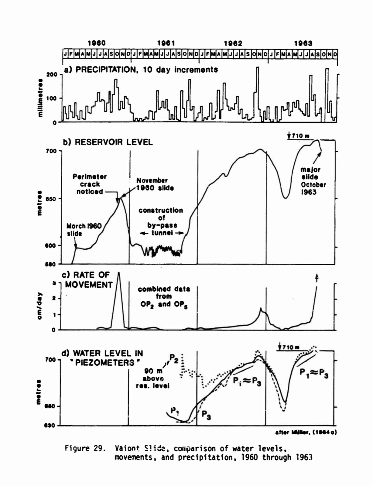
The number 700 was already in use. On 3 May 1962, two months before the report, SADE had asked Rome to raise the experimental filling to 700, writing that the movement on the Toc “is always in the phase of stopping and that the situation is entirely reassuring”, and the Dam Service granted it on 8 June. The lake had been raised from 600 to 650 metres between October 1961 and February 1962 with almost no movement, and on to 695 by October 1962 with the fastest point still under a centimetre a day. Müller’s hypothesis seemed to be confirming itself. The observation that the slope moved faster only when a new band was wetted for the first time, he wrote in 1964, “led authorities and technicians to the conviction that a gradual stabilization of the moving mass would be brought about by raising the water level in individual steps”.
In November 1962 the lake reached 700 metres. It rained 414 millimetres at Erto that month, and the slope’s speed rose to 1.2 centimetres a day, a third of what it had been in November 1960. The lake was let down, slowly, to 650 by the end of March 1963, and the movement stopped. Then, on 20 March 1963, SADE asked for 715. The Genio Civile granted it on 4 May, because “the work, already subjected to experimental filling to level 700, has shown normal behaviour”, because the movement on the Toc “presents no abnormal facts and is continuously controlled”, and because the testing commission was in favour. The parliamentary commission, reading these papers in 1965, found them formally in order and then wrote: “There remains, however, a reason for perplexity in the fact that the model tests had indicated in level 700 the limit held to be safe also for a possible overtopping wave towards the Vajont gorge and Longarone.”
The third filling began in April 1963 from 650. The lake was at 695 by early June and at 705 by the middle of July, with the slope moving less than half a centimetre a day. On 1 July the commune of Erto and Casso lifted its ban on going down to the shore. In the middle of August the water rose towards 710, nearly 200 millimetres of rain fell in ten days, and the slope’s speed went to about a centimetre a day. At the beginning of September the lake reached 709.40 and was held there, “with some slight variation never exceeding level 710”, until near the end of the month. On 2 September an earthquake cracked houses at Erto; Caloi wrote that it was “a shock of tectonic origin” with no connection to the slope. In the middle of September a new crack opened near the Punta del Toc, where the slide of 1960 had been, and the lower west of the slope was moving 3.5 centimetres a day. On the 18th Biadene and Pancini met their consultants at the dam and agreed that the lake would not go up to the 715 that had been authorised, and would come down if the instruments got worse. On 26 September the drawdown was ordered. On 1 October Pancini went on holiday.
What it looked like from inside
From the first of October the lake fell about a metre a day, from 710, and the mountain moved faster. Biadene was in Rome on the 2nd with graphs, asking for Penta, who was ill. On the 7th the acting director at the dam, Beniamino Caruso, asked for the houses still lived in on the Toc to be cleared, for the shores of the lake to be closed below 730 metres, and for the road along the left bank to be shut. On the 8th a telegram went from ENEL in Venice to the mayor of Erto and Casso: “Acceleration movement Toc zone left reservoir Vajont makes necessary prudential immediate evacuation of persons stop.” Thirty-five families moved to Casso. The carabinieri reported that “at present no dangers exist stop public order normal situation followed”.
The Genio Civile of Belluno wanted it in writing and sent Bertolissi, the government assistant, to the dam. His report is dated 8 October and reached the office on the morning of the 9th. “From the middle of August an increase has occurred in the velocity of lowering of the points of the Toc zone under control,” it said, reaching in the first days of October “values of the same order as those measured during the landslide of November 1960: the velocity of about 0.5 cm/day passed, at the end of September, to 5 cm/day, touching today the value of about 10 cm/day.” The company had lowered the lake from 710 to 702.50 at a metre a day and meant to go on “so as not to provoke dynamic imbalances”. Then the model spoke, at second hand, for the last time. “From tests carried out on a model it has resulted that with the maximum filling and with the instantaneous collapse of the landslide the consequent wave would reach a height of 25 metres.” A slide of the Toc, he went on, “is foreseen in successive stages, in blocks”, as in 1960, and so “it would be deduced that the dam should withstand the stresses consequent on the possible landslide, and that a freeboard of 30 metres on the road level together with the other measures should be sufficient for the safety of all persons. All this does not lessen the gravity of the situation, for which instructions are awaited from this Service.” The road level was 730 metres. Longarone, below the dam, was not in the report, because nothing in the model had reached it.
There was one more reading in the report. The piezometers in the left bank, Bertolissi wrote, had been falling with the lake, a metre a day, as the hypothesis said they should. In 1985 the Corps of Engineers’ authors found that one of them, P2, had stood 90 metres above the reservoir when it was first read in 1961, with a tip probably not well sealed, so that the real pressure under the slide was higher still.
Biadene wrote his letter on the 9th. He had been at the dam the day before with Caruso, “who follows things closely”, and would go up again on Friday the 11th with the men from Rome. “Yesterday we telegraphed the mayor of Erto and the prefecture of Udine,” he wrote, “asking that the order forbidding traffic on the road be restored; meanwhile the reservoir is falling a metre a day and this morning should be at level 700. I think of reaching level 695, always with the aim of creating a band of safety for the waves. The population is totally evacuated since yesterday evening and stays on the spot only during the day for the potato harvest. In all this affair what is really strange is that no falls of material are yet seen along the edges of the water. I am sorry to give you so much bad news and to have to make you come back early.” The ministerial commission later put the fastest movement on 9 October at 20 centimetres a day. That evening the carabinieri blocked the road. No warning went to the communes below the dam. Kiersch, an American geologist who came three weeks later, was told that about 8 October the engineers had realised “that all the observation stations were moving together as a ‘uniform’ unstable mass”, and expected it to come down about the middle of November. The two men who took the readings on the slope, the engineer Cicco of the drilling contractor and the surveyor Dal Prà of ENEL, did not move their families, and died with them.
At about a quarter past ten that night a man in Casso, 260 metres above the lake and on the far side from the slide, was woken by a loud, continuous sound of rolling rocks, and thought nothing of it, because talus slides were common. It went on and grew louder. It was raining hard. At about twenty to eleven a very strong wind struck the house and broke the windows, the house shook, and the roof lifted so that rain and rocks came into the room “for what seemed like half a minute”. Kiersch took the account down a fortnight later; it is the only one from a witness on the mountain, because nobody who watched from the dam lived.
What happened
The experts of the ministerial commission that reported in January 1964 described it in words the parliamentary commission adopted. “Suddenly, at about 22:39 on 9 October,” they wrote, “the slope changed its behaviour and set itself in motion with enormous velocities which reached 50 to 60 kilometres an hour. That is, suddenly, in perhaps 100 seconds or at most a few minutes, the velocities became five or six million times greater than the greatest observed before.” It did not come down in blocks. The front of the slide kept the shape of the slope it had been; the mass, limestone shattered to the centimetre, moved “as a true and proper plastic body” and stayed whole. It was 1.7 kilometres across and up to 330 metres thick, 280 to 300 million cubic metres by the ministerial experts’ estimate, 270 million by Edoardo Semenza’s. The Corps of Engineers put its speed at 20 to 30 metres a second, the whole 300 to 400 metres of travel done “in less than a minute”. It filled the lower half of the reservoir and ran up the far side to 165 metres above the lake.
The water went two ways. Up the lake the wave ran to Erto and stopped 40 metres above the shore; the village, at over 760 metres, was mostly spared, and Casso lost its two lowest houses. ENEL’s experts found that on the right bank, opposite the slide, the water had reached 930 metres, “fully 200 metres above the level of the water before the landslide”; the slide had acted “as a piston”. Towards the dam the gorge narrowed and the water rose. It went over the crest, the Corps of Engineers wrote, “reaching over 100 m above its crest”, fell 400 metres into the gorge, and came out into the Piave valley a mile away still some 70 metres high. About 30 million cubic metres of water went down the gorge. Longarone stood on the far bank of the Piave facing the mouth of the Vajont. At dawn, the parliamentary commission’s report says, “the villages of Longarone, of Pirago, of Fornace, of Faè and part of Castellavazzo in the Piave valley, of Pineda and San Martino on the edges of the lake, no longer existed”.
The dam stood. The slide and the wave together loaded it, Kiersch estimated, with some four million tons, and neither the shell nor the abutments were damaged. Forty-five men living in barracks on its crest were killed. “For days and weeks,” the commission wrote, “it was not even possible to know the number of the victims and there was talk even of 4,000 and 5,000 dead. Then, from a careful inquiry of the Ministry of the Interior, it resulted that the victims were 1,917, of whom 1,450 at Longarone, 109 at Castellavazzo, 158 at Erto and Casso and 200 persons from other communes.” The reservoir was abandoned with the mountain in it.
Tina Merlin wrote her dispatch from Belluno on 10 October, and L’Unità printed it the next day under the headline “L’Unità was prosecuted for having denounced the danger”. It began “It was a genocide”, and it said what she had been writing since 1959: that the company “knew that Monte Toc was itself part of that landslide and that it was foreseeable that the water let into the basin would slowly erode the subsoil and cause disasters”. Her first article, on 5 May 1959, had cost her and the paper’s editor a prosecution in Milan for spreading “false, exaggerated and tendentious news capable of disturbing public order”; they were acquitted on 30 November 1960. On 21 February 1961, under a headline that said “an enormous mass of 50 million cubic metres threatens the life and goods of the inhabitants of Erto”, she had asked: “It cannot be known whether the collapse will be slow or whether it will come with a terrible crash. In the latter case the consequences cannot be foreseen.” Fifty million was a quarter of what Müller had told SADE, and more than anyone outside the company had been told. “I am writing these lines,” she ended on 10 October 1963, “with my heart gripped by remorse for not having done more to induce the people of these lands to rebel against the mortal threat that has now become a tragic reality. Today, however, one cannot only weep. It is time to learn something.” Her four years of articles, and the trial of 1960, are in “The correspondent from Belluno”.
After
Three inquiries sat at once: the Minister of Public Works’ commission under Carlo Bozzi, appointed on 11 October 1963, which reported on 16 January 1964 and gave the time, 22:39, and the level, 700.4 metres; ENEL’s own under Marcello Frattini; and from July 1964 a commission of fifteen senators and fifteen deputies under Leopoldo Rubinacci, which reported on 15 July 1965 with two minority reports attached. On the slide the majority wrote that “with the knowledge acquired, it is still not known why the landslide fell”, nor how it had taken on the size, unity, compactness and speed that made the wave. On the people it concluded “that the event, as it manifested itself, was foreseen by no one, and that the forecasts formulated, even considered in their worst combination, excluded dangers for the public safety”. The Communist minority answered: “The tragedy could and should have been avoided. We reject the appeal to fatality or to the unleashed forces of nature.” It found it “most grave” that Ghetti’s report “was never transmitted to the Ministry of Public Works”, and drew a distinction the majority had not: “One must distinguish between foreseeability and probability. An event productive of damage may be foreseeable but not probable; its foreseeability is enough to create a situation of responsibility.”
The courts took until 1971 to decide which was right. Eleven men were committed for trial in February 1968, Ghetti among them. Pancini killed himself on 24 November 1968, two days before the trial opened at L’Aquila, where it had been moved. On 17 December 1969 the court convicted three, Biadene, Batini and Violin, of manslaughter, six years with two remitted, acquitted the rest and found that the slide had not been foreseeable; L’Unità reported the survivors in the courtroom shouting “Let them kill another two thousand people! Put us in prison, we who have lost our children”. The appeal court on 3 October 1970 found the landslide foreseeable, convicted Biadene and Sensidoni of landslide, flood and manslaughter, and acquitted Ghetti and the others. The Court of Cassation on 25 March 1971 made it five years for Biadene and three years and eight months for Sensidoni, three of each remitted, for a single crime: flood aggravated by foresight of the event. Nobody else was convicted of anything. The companion piece, “The commission and the court”, follows the three reports and the three verdicts.
The engineers read the slide for twenty years. In 1985 the US Army Corps of Engineers published a two-volume report by Alfred Hendron and Franklin Patton, who had gone back to the mountain with Edoardo Semenza, mapped the surface the slide had left, and found clay on it: multiple layers of weak clay, a few centimetres thick, along the base of the slide, of a kind Müller had expressly said was not there. The 1963 slide, they concluded, “was a reactivation of an old slide”. And they put the filling record beside the rain. Movement had come three times, in October 1960, in November 1962 and in October 1963, each time after heavy rain; where the same reservoir level had produced different speeds, the higher speed went with the wetter month. “The erroneous assumption,” they wrote of Müller’s hypothesis, “was that all other factors were remaining constant and the reservoir level was the main variable controlling the stability of the slide. In fact, rainfall was significant and was not remaining constant.” Plotting the lake’s level against the rain of the preceding weeks gave a line, a “failure envelope”, with the three movements on one side of it and the quiet months on the other. Extended, it said that the slope would have gone without any rain at about 710 to 720 metres, and that without any reservoir it would have gone in a wet enough month, which it probably had, before history. Their last word on the question that had been put to the gravel was this: “The high velocity acquired by this slide mass was easily the most unforeseen phenomenon associated with the Vaiont Slide.” The companion piece, “The mountain, reread”, sets out what they found.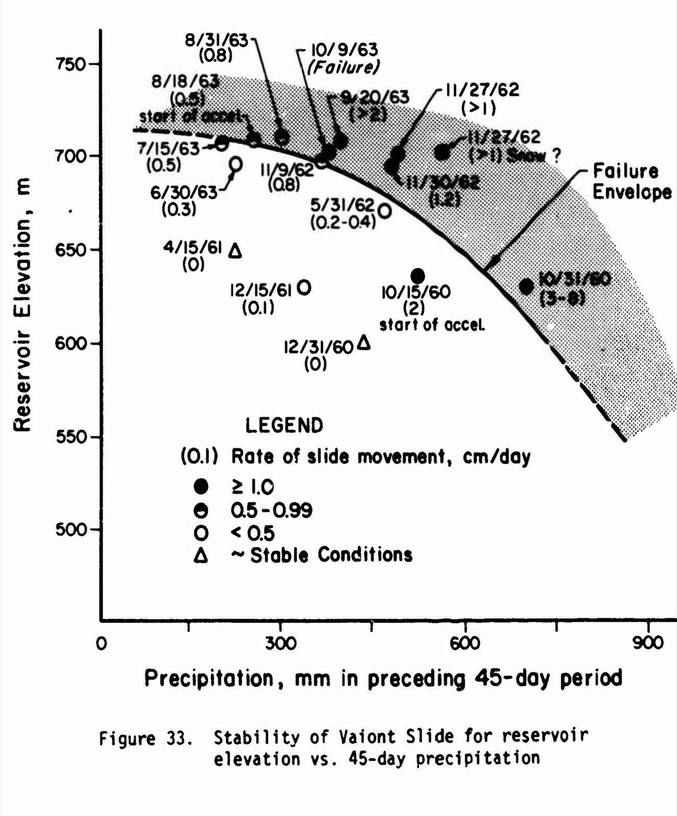
What it taught
The Vajont is remembered as a dam disaster, and the dam was the one thing in the valley that did what it was built to do. What failed was an experiment. From November 1960 the slope of Monte Toc was run as one: a hypothesis, that the mountain’s speed could be regulated by the water; an apparatus, the lake, raised and lowered by the metre; instruments, the pillars on the slope read every day, the piezometers, the seismograph; and a control, the model at Nove, which was to say how high the water could stand before a slide would hurt anyone. Every authorisation from Rome called it an experimental filling, and that was the right name. The lesson is in how the experiment was read.
A model answers the question it was built for, and no other. Ghetti’s model was asked how high a wave a landslide would throw and how much water would go over the dam, for a slide of a given size falling in a given time, and it answered honestly, with every caveat written down: the forecasts of the event were “as uncertain as could be”, the fall times were already faster than anyone expected, the material was gravel because clay could not be modelled, and the wave below the dam had not been looked at. The one question whose answer would have changed everything, how fast 270 million cubic metres of shattered limestone on wet clay would move once it started, was not a question the model could take, and nobody put it. The mountain beat the gravel’s fastest run, coming down in one piece in less time than the model had given either half. When the number 700 travelled out of the report it went without the caveats. In one of the last documents written before the slide, the government assistant’s report of 8 October, the model had become a single sentence, “the consequent wave would reach a height of 25 metres”, and a freeboard of 30 metres “should be sufficient for the safety of all persons”. The wave reached a hundred metres over the dam, and the people it killed were in a town the model did not contain.
A hypothesis confirmed by the second trial can be killed by the third. Müller’s idea that the slope could be controlled by the lake was not foolish, and the second filling bore it out: the water went back to 650 and the mountain did not move, went on to 700 and moved a third as fast as before, and stopped when the lake was let down. What the second filling had actually shown, Hendron and Patton found, was that the winter of 1961 to 1962 was dry. The variable that mattered as much as the lake, the rain, was not in the hypothesis, so it was not in the reading of the result; and the third filling, in a wet August and September, took the slope across a line nobody had drawn. Carlo Semenza, who did not live to see it, had put the difficulty exactly in a letter of April 1961: “How much the present phenomena are due to the rains, exceptional and exceptionally continued, of the second half of last year, and how much instead they are really due to the reservoir, nobody will ever know; the fact is that unluckily the two possible causes coincided in time.” Then he asked the question the next two years were to answer. “But what will happen with the new filling?”
The instruments spoke, and were read for the wrong quantity. The pillars on the slope were read daily and the figures went to Rome fortnightly, and from the middle of August 1963 they said, in a line that steepened every week, that the mountain was accelerating: half a centimetre a day, one, three and a half, five, ten, twenty. That was read, by everyone, as the approach of a slide like 1960’s, a front falling off in blocks, and the lake was let down a metre a day to make it safe, which is what the model said to do. The same figures, read as the Corps of Engineers read them twenty years later against the rain, said that the slope was past the envelope and that the whole of it was going. “The greatest gaps in the data,” Hendron and Patton wrote, were “the lack of substantive water pressure data” and “the lack of reliable movement records along the failure plane”: the two quantities that decided the outcome were the two nobody had measured, because the hypothesis did not need them. The instruments that were there were good. They were pointed at the wrong question.
Listen to the warning that uses the wrong number. Tina Merlin’s 50 million cubic metres in February 1961 was a quarter of the figure SADE had, and her mechanism, water eroding the ground under Erto, was not the one that acted. The commission’s majority found that the complaints of four years had been about Erto and about expropriated land, and that “nobody had even indirectly hypothesised the catastrophic phenomenon of the overtopping of the wave above the dam”. That is true, and it is the wrong test. Her question of February 1961, whether the collapse would be slow or come “with a terrible crash”, was the one question put in writing in four years that the model could not answer and the mountain did. A warning is not to be marked against the detail it gets wrong but against the question it asks.
Check the story before you learn from it. The slide was 270 million cubic metres to Semenza, 280 to 300 million to the ministerial experts, over 240 million to Kiersch; the dead were 1,917 to the Ministry of the Interior, 2,043 to the Corps of Engineers, “almost 3,000” to Kiersch; the wave went over the dam by 100 metres in the American report and by 250 in the encyclopaedias; and the courts said in 1969 that the slide was not foreseeable and in 1970 that it was. What the record carries without argument is the shape of the thing: a slope known from 1960 to be an old landslide; a hypothesis that it could be let into the lake slowly by controlling the water; a model that gave 700 as safe, with its caveats, for a slide that fell in minutes; a lake taken to 710 and held there through a wet September; a mountain moving twenty centimetres a day; and a letter that said the water would be at 700 by morning, “always with the aim of creating a band of safety for the waves”. The lesson is not that the engineers were careless. They measured, consulted, modelled and reported, and two of them stayed on the mountain with their families. It is that an experiment on a living system has to be designed to find out what it does not want to know, and that a number taken from a model is only as safe as the question the model was asked.
Sources
- A. J. Hendron Jr. and F. D. Patton, The Vaiont Slide, a Geotechnical Analysis Based on New Geologic Observations of the Failure Surface, Technical Report GL-85-5, US Army Corps of Engineers, Waterways Experiment Station, June 1985, two volumes. Volume I: the description of the slide and wave, the chronology of 1928 to 1964, the correlations of reservoir level, rain and movement with the quotation from Müller (1964) and the “erroneous assumption”, the failure envelope, the velocities (Tables 12 and 13), the conclusions, and Figure 29. Volume II, Appendix G: Edoardo Semenza’s Summary of Geological Studies on the Slide at Vaiont, 1959–1964 in the report’s translation, with the hydraulic model, the diagnosis of 1961, the fillings and the collapse. US government works, read on archive.org. Volume I, Volume II
- Commissione parlamentare d’inchiesta sul disastro del Vajont, Relazione finale, Senato della Repubblica, IV Legislatura, Documento n. 76-bis, 15 July 1965, with the two minority reports. The authorisations of 1960 to 1963 and their reasons, Müller’s report of 3 February 1961, the meeting of 16 November 1960, Carlo Semenza’s letter of 20 April 1961, the events of August to October 1963, Bertolissi’s report and Biadene’s letter, the toll, the ministerial and ENEL experts on the slide, the majority’s conclusions, and the minority’s account of Ghetti’s report, of Tina Merlin’s articles and of the Rizzato affair. Read in full in the scan on certifico.com; the quotations are in my translation. certifico.com
- Augusto Ghetti, Esame su modello degli effetti di un’eventuale frana nel lago-serbatoio del Vajont, Istituto di Idraulica e Costruzioni Idrauliche dell’Università di Padova, Centro modelli idraulici “E. Scimemi”, for SADE, Padua, 3 July 1962. The model’s scale, construction and material, the two series, the tables of the twenty-two runs, the results at 722.5, 700 and 670 metres, the conclusion and the recommendation. Read in full in the scan posted by ProgettoDighe; the quotations are in my translation. progettodighe.it
- Carlo Semenza, “La diga del Vaiont,” Il Noncello, no. 14, Pordenone, 1960, pp. 50–56. The dam’s dimensions, the models at Bergamo and the 350 instruments. archive.org
- George A. Kiersch, “Vaiont Reservoir Disaster,” Civil Engineering, March 1964, pp. 32–39. The dam’s height and the four million tons, the 1960 slide as a million cubic metres, the rates of creep in the last three weeks, the realisation of 8 October, the mayor’s notice of a 20-metre wave, the time of 22:41:40 and the account of the resident of Casso. archive.org
- Tina Merlin, “L’Unità fu processata per aver denunciato il pericolo,” L’Unità, 11 October 1963, p. 2, with the reproduced headline of 8 November 1960; the front page of the same day reproducing the headline of 21 February 1961. The titles of 5 May 1959 and 21 February 1961 and the sentence on the slow collapse or the terrible crash are quoted as the parliamentary commission’s minority report gives them; the national edition in the paper’s archive does not carry the Belluno pages. In my translation. archivio.unita.news, 11 October 1963, p. 2, p. 1
- L’Unità, 18 December 1969, p. 1 (“Solo tre lievi condanne!”); 4 October 1970, p. 5 (“Vajont: sono colpevoli di tutto. Ma soltanto due e lievi le condanne”); 26 March 1971, p. 5 (“Definitive le condanne per il Vajont”). The three verdicts and the survivors’ words. 1969, 1970, 1971
- Senato della Repubblica, Archivio storico, Inventario della Commissione parlamentare d’inchiesta sul disastro del Vajont, 2003. The commission’s law, membership, working groups and the dates of its reports. certifico.com
- Wikipedia (Italian), “Disastro del Vajont,” for the names of the eleven committed for trial, the date of Pancini’s death and the detail of the three verdicts, checked against L’Unità. it.wikipedia.org