At eleven o’clock on the night of 10 February 1907, four miles south of the boundary between California and Mexico, the Colorado River stopped going west. For fifteen days and five hours, trains of steel side-dump cars that the men called battleships had been running out on to two pile trestles across a gap in the river’s west bank, eleven hundred feet wide and forty feet deep, and tipping rock into the current, train after train, day and night, faster than the river could carry it away. The rock came from a quarry at Andrade, four miles up the line, and from Patagonia in Arizona and Colton in California, hundreds of miles in each direction; for the better part of three weeks almost no freight left the port of Los Angeles, because the Southern Pacific had a thousand flat cars at the break. The pile under the trestles rose, and the river rose with it, and spilled over it, and on the night of the tenth it rose high enough to find its old bed to the south, towards the Gulf of California, and the gap went quiet. By then 2,357 carloads of rock had gone into it. One man had gone in with them.
The gap had begun as a cut sixty feet wide. It had been dug with a dredge in about three weeks in the autumn of 1904, to let water out of the river and into a canal, by a company that could not afford the gate to control it and had not been given permission to build one. Between the cut and the night the river stopped going west lay two years and four months, five floods in one winter, the drowning of a salt works, forty miles of main-line railway moved uphill, two towns partly eaten by a stream that had not existed, a lake fifty miles long in a basin that had been dry since the Spaniards, and something over three million dollars that nobody ever paid back. The cut had been made on the strength of a number. The number was twenty-seven.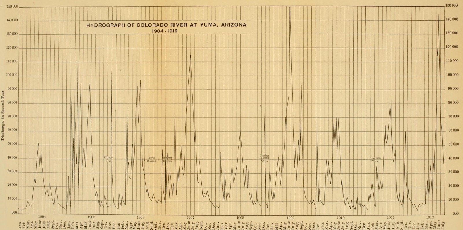
Who ran it
South of the Southern Pacific’s main line between Yuma and Los Angeles, and west of the Colorado, lies a basin that the maps of 1904 called the Colorado Desert and the people moving into it called the Imperial Valley. Its floor is below the sea; the lowest point, a bed of salt near a siding called Salton, was 278 feet under sea level, and the railway itself ran for forty miles below the sea. The Colorado had made the basin, building a delta across the head of the Gulf of California that cut off a northern arm of it, which dried. In 1891 a flood had gone over the bank below Yuma and run down the old channels, the Alamo and the New River, to the salt beds, and made a lake there for a season. Then it had gone back.
In 1892 a young engineer named Charles Robinson Rockwood went down the river for a group of promoters and took up the old idea of putting the river on the basin’s floor; in April 1896 he and his associates incorporated the California Development Company under the laws of New Jersey, with a promoter named Anthony Heber as president and Rockwood as engineer. In April 1900 George Chaffey, who had built the irrigation colonies at Ontario and Etiwanda, signed a contract to build the canal with his own money. He put the heading at Hanlon’s, a few hundred feet north of the boundary, with a timber gate; ran a canal south into Mexico for some four miles; and used forty miles of the Alamo’s old channel as the main canal, back across the line to Sharp’s Heading, where the valley’s own canals began. Water reached the valley in the summer of 1901. Chaffey fell out with Rockwood and Heber and left in February 1902.
The land was public land, taken up by homestead and desert entry; the company sold the settlers water rights, and a Mexican subsidiary held the works in Mexico. By the spring of 1905 the Reclamation Service’s own measurement put 79,591 acres under irrigation; the company said 125,000 were in cultivation; the valley’s spokesmen said 10,000 people lived there, in five towns. The other interests on the river were a railway, a salt works and a government. The Southern Pacific’s transcontinental line had crossed the sink since 1876 and did not expect to be wet. The New Liverpool Salt Company worked the beds at the bottom. The Reclamation Service, under Frederick Newell, had begun in 1905 to build the Laguna dam across the river above Yuma, and its consulting engineer, Carl Grunsky, watched the company’s works from the other bank with professional interest and no power.
What they were trying to find out
The experiment began with silt. The Colorado below the Gila is a river of mud, and Chaffey’s canal silted from the first season. By the late summer of 1904 the four miles below Hanlon’s could not carry what the valley needed, crops were dying, and the farmers were filing damage claims.
Rockwood wrote his own account of what he decided, five years later, for a newspaper in Calexico; it is the nearest thing to a statement of the hypothesis. “As soon as the summer flood (1904) dropped and I discovered that instead of the bottom being lower, it was approximately 1 ft. above that of the year previous,” he wrote, “we adopted the only means at our command to attempt to deepen the channel.” The company’s two dredges would have taken all winter. “We were confronted then with the proposition of doing one of two things, either cutting a new heading from the canal to the river below the silted 4-mile section of the canal, or else allowing the valley to pass through another winter with an insufficient water supply. The latter proposition we could not face for the reason that the people of the Imperial Valley had an absolute right to demand that water should be furnished them, and it was questionable in our minds as to whether we would be able to keep out of bankruptcy if we were to be confronted by another period of shortage in this coming season of 1904-1905.”
So the first claim was hydraulic: a cut of 3,300 feet from the river to the deeper canal four miles below the boundary would bring water to the valley for the winter. The second claim was about time. The cut would have to be closed before the summer flood, and the company believed it could be, “by the same means that we had used in closing the cut for three successive years around the Chaffey gate,” a barrier of brush and earth thrown across a by-pass each spring. The third claim was a reading of a record. The Southern Pacific had kept a gauge on the river at Yuma since 1878. “We had before us, at the time,” Rockwood wrote, “the history of the river as shown by the daily rod readings kept at Yuma for a period of twenty-seven years. In the twenty-seven years there had been but three winter floods. In no year of the twenty-seven had there been two winter floods. It was not probable, then, in the winter of 1905, that there would be any winter flood to enlarge the cut made by us.”
Underneath the three was an assumption about a gate. The Mexican concession of May 1904 required the company’s plans to be approved by the Mexican government’s engineers before any work was built, and the cut itself had no permission. “We hesitated about making this cut,” Rockwood wrote, “not so much because we believed we were incurring danger of the river’s breaking through as from the fact that we had been unable to obtain the consent of the Government of Mexico to make it.” A telegram came from the company’s attorney in Mexico City to go ahead, and they found out afterwards that he had got no permit, “but had simply obtained the promise of certain officials that we would not be interfered with, providing that plans were at once submitted for the necessary controlling structures to be placed in this heading.”
The reading the company would take, then, was the water in the canal; the reading it would not take, because there was no gauge for it, was the width of the cut. The government’s engineers read the design differently from the start. Newell wrote afterwards that the cut was made “much against the advice of the engineers,” and Grunsky put it in one sentence: “Neither of these connections between river and canal, commonly referred to as the Upper and Lower Mexican Headings, was provided with regulating gates.”
What they built
“We began the cut the latter end of September and completed it in about 3 weeks,” Rockwood wrote. The dipper dredge Alpha dug it, about four miles below the line, from the river’s west bank to the canal. Rockwood put its width at “about 60 ft., as originally cut with the dredger”; Newell, Grunsky and the valley’s own historians say forty or fifty feet, and six to eight feet deep. It was first used, Grunsky reported, on 26 October 1904.
“As soon as the cut was decided upon, elaborate plans for a controlling gate were immediately started and, when completed early in November, were immediately forwarded to the City of Mexico for the approval of the engineers of the Mexican Government, without whose approval we had no authority or right to construct the gate. Notwithstanding the insistence of our attorney in the City of Mexico and various telegraphic communications insisting upon this approval being hurried, we were unable to obtain it until 12 months afterward, namely, the month of December, 1905.” By then the gate’s site was a river.
What the cut connected is the rest of the design. The river below Yuma runs on the crest of its own delta: towards the Gulf the fall from the heading was about a hundred feet, towards the bottom of the Salton Sink nearly four hundred, through soft silt. The heading itself had enough fall, Grunsky noted, “to give the water a scouring velocity.” That was the point of it. Cory, who spent the next four years undoing the cut, wrote that the company’s difficulty up to then “had not been any tendency whatever to divert the entire river, but, very much to the contrary, to induce enough water to go that way. Up to that time, a head-gate to prevent too great a quantity of water from entering the canals was of far less importance than some means of maintaining their carrying capacity. That a head-gate should have been provided, is, of course, self-evident.” The company’s whole experience of the river was of a river that would not come in. Chaffey had laid out the main canal of 1900 so that its bank “would be made to serve as a levee to prevent the flood waters of the Colorado from finding their way into the Alamo.” The cut of 1904 opened that levee.
Five floods
The first flood came down about 2 February 1905. It did no harm; it silted the mouth of the cut, and the dredge had to go through again. A second came on the nineteenth and did the same. “We were not alarmed by these floods,” Rockwood wrote, “as it was still very early in the season.” A third came at the end of February, “and this was sufficient notice to us that we were up against a very unusual season, something unknown in the history of the river as far back as we were able to reach.” The record of twenty-seven years had held three winter floods. The winter of 1905 had produced three in one month.
The company set out to close the cut as it had closed the by-pass at the Chaffey gate, with piles, brush and sand bags. “The dam was very nearly completed,” Rockwood wrote, “when a fourth flood coming down the river swept it out. Work was immediately begun on another dam which was swept away by the fifth flood coming down during this winter season.” Meanwhile the company was fighting itself over a loan from the Southern Pacific, $200,000 against a majority of the stock and a president of the railway’s choosing; an assistant, C. N. Perry, began sinking brush mattresses across the cut with $5,000 put up by the farmers themselves, and Rockwood, back from the stockholders’ meeting on 17 June with the summer flood over the country, stopped him. “At this time,” he wrote, “the lower intake had been enlarged from a width of about 60 ft., as originally cut with the dredger, to a width of possibly 160 ft., and it did not then seem probable that the Colorado River would turn its entire flow through the cut, but as the waters of the river began to fall, the banks of the intake began to cave and run into the canal, the banks of the canal below the intake fell in and, as known by most of the residents of the valley, the entire river began running through the canal and into the Salton Sea in the month of August of this year of 1905.”
On 20 June 1905 the loan was signed and the Southern Pacific took over the management, with Epes Randolph, president of the Harriman lines in Arizona and Mexico, as president of the development company. Randolph went down himself, found it worse than the company had represented, and told Edward Harriman, the railway’s president, that the river could not be controlled for $200,000; the cost “might easily run into three quarters of a million dollars.” Kennan, who had Harriman’s papers, gives the exchange that followed. “Are you certain you can put the river back into the old channel?” “I am certain that it can be done.” “Go ahead and do it.”
The water went where the slope sent it. By July it had reached the rails along the sink, and the salt works went under. On 22 and 23 September the Reclamation Service measured the river at Yuma at 6,063 second-feet and the old channel below the heading at 175: “over 97 per cent of the entire Colorado River was then flowing into the canal.” Cory, sent to the river by Randolph that summer, wrote that he, “like practically all other engineers who gave the matter cursory consideration,” felt then that the cut “was a blunder so serious as to be ‘practically criminal.’”
Everybody with an opinion had a plan: a concrete gate on rock at Pilot Knob, which was the consulting engineer Schuyler’s; a wooden gate beside the break with a by-pass through it, which was Rockwood’s; a barrier dam of piling and brush across the river’s west channel, which was a railway bridge engineer’s named Edinger. Randolph tried all three. On 29 November 1905, with 260 white men and 80 Indians on the Edinger dam, a flood came down the Gila, the Colorado’s flashy tributary, and read 31.8 feet on the Yuma gauge, 116,000 second-feet by Cory’s figure, with so much driftwood that the river was covered with it. The dam went before the peak. It was Thanksgiving Day. When the water fell, the old channel had silted higher than before, the new one was cut deeper, and the whole river went west again. The cut was now 600 feet wide. Five attempts had cost about $100,000.
What it looked like from inside
Through the winter of 1906 the company built both gates. Rockwood’s was a wooden A-frame flashboard gate 200 feet long on piles, in the old canal beside the break, finished on 18 April, “the largest and most daring design ever made,” Cory wrote, “for a wooden A-frame, flash-board head-gate,” at a cost of about $122,500. On 18 April the earthquake broke San Francisco, and Randolph went to the ruined city to find Harriman. “There, in the bustle and confusion of temporary offices, with the ruins of San Francisco still smoking,” Cory wrote, “with the wonderful railway system which constituted Mr. Harriman’s life work crippled to an unknown extent, and with the financial demands resulting from the disaster impossible to determine, Mr. Randolph succeeded in inducing Mr. Harriman to advance an additional $250 000 for controlling the Colorado River and protecting Imperial Valley. It has always seemed to the writer that this was really the most remarkable thing in the whole chain of extraordinary happenings.” On 19 April Rockwood resigned, and Cory became chief engineer at thirty-five. By then the summer flood had begun, and the gate could not be used until it had passed.
The flood of 1906 widened the break from 600 feet to about 2,700, more than half a mile, and sent the whole river into the valley. What it did there, the overflow at Calexico and Mexicali, the waterfall that walked up the New River at a foot a minute and through the towns, the forty-three miles of gorge cut in nine months, the sea rising nearly seven inches a day in June and the railway climbing from one contour to the next, is in the companion piece “The New River”. The chasms are the valley’s drainage system now, and Cory counted them its greatest gain.
The men who would put the river back assembled through the summer. Randolph set the terms. When Cory suggested that interests so large justified a board of engineers, “he answered that he would regard 100 ft. of good strong brush mattress in place on the river’s bottom as more valuable than the report of any Board of Engineers which could be gotten together.” Nearly fifty engineers of reputation had visited the break; “no two,” Cory wrote, “agreed on any one plan,” and on one point only was there accord: that the situation was “desperate,” “without engineering parallel,” and that there was “little more than a fighting chance.” Practically every one of them thought a dam of rock dumped into the stream unworthy of consideration: the rock would sink out of sight in the silt, and the water going over the pile would pluck one stone from the top and then the rest. Randolph listened and went on. A branch railway was laid from the main line to the break, a quarry was opened on the granite at Andrade, three hundred forty-five-yard battleships came from the Lucin cut-off across Great Salt Lake, and the Indian Service brought six tribes from Arizona and Mexico, about two thousand people in a camp of their own on the Arizona bank, four hundred of them at work for twenty cents an hour. A work train went into Yuma every night for provisions, “and it always carried a considerable number of cheerful capitalists out and sadder and wiser men in.” The companion pieces “Battleships” and “Fifteen days” go through the preparation and the two closings as Cory reported them.
Work began at the break on 6 August. Two shifts wove a brush mattress a hundred feet wide across the river bed in twenty working days, then a second on top of it; a railway trestle went across on it, ready for trains on 14 September; the battleships dumped rock between its bents, and a head of six feet built up on the dam with, Cory said, no difficulty whatever. The dredges cut the by-pass to Rockwood’s gate, and by 10 October 12,850 of the river’s 14,300 second-feet were going through it. The plan was working. But the gate had begun to speak. On 3 October the earth filling of its north abutment settled; two days later a wing wall spread at the bottom; the gate itself buckled upward a third of a foot, slowly, over twenty-four hours; the upstream apron tore up in pieces that the current threw against the A-frames; drift piled against them until the head on the gate was 4.4 feet. “These indications of weakness showed that it would not be safe to use the gate after closing the break,” Cory wrote, “and that it would be very fortunate if it held until this could be accomplished.” A trestle was thrown across just above it, to bury it in rock rather than set its flashboards.
Eleven in the morning, half past two in the afternoon
On 11 October 1906 the trestle above the gate was finished in the morning. “When the first rock train was slowly pushed over the trestle, at 11 A. M., three bents of the frame trestle settled and wrecked the train, fortunately injuring no one seriously.” Cory always believed that if the loaded battleships standing ready had been dumped, the gate would not have gone. “Be that as it may, at 2:30 P. M., without any warning, the gate suddenly buckled up at a point about one-third of the way from the south abutment, and the larger portion, from there to the other abutment, floated down stream about 200 ft., where it lodged.” The 4.4-foot head behind it came through as a wave carrying the wreckage. The by-pass was the river now.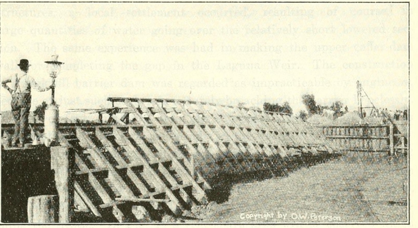
Four months’ work and $122,000 had gone down the by-pass; the fifth attempt had failed as completely as the four before it. What was left standing was the thing nobody had believed in. The water above the diversion dam drained away, and the dam stood dry, and could be examined: an ever-growing proportion of rock to brush, with a surprisingly small leak, holding a head of six feet “without any of the troubles prophesied for constructing rock fill dams in streams.” The quarry could now turn out 5,000 cubic yards of rock a day. “It was felt that with these facilities,” Cory wrote, “rock could be put into the stream faster than the water could carry it away.”
So they repaired the trestles across the by-pass, threw a third across the stream above the wreck of the gate, and dumped. There was no mattress under any of the new dams; the brush was gone. A second trestle went across the main break thirty feet upstream of the first, and from the two of them a rock fill dam turned all the water, 9,270 second-feet, down the old channel, “actually closing the break on November 4th. That is, after working on other lines continuously for 15 months, the stream was controlled by a rock fill dam in 24 days. In other words, the rock fill barrier dam plan, which had not been advocated, or indeed seriously considered, by a single man, proved to be a very simple and efficient, though expensive, method of re-diverting the river.” Newell and Walcott, in Washington, dated it the sixth. A thousand men were at work on the day of closing; 1,690 carloads of rock, 841 of gravel and 808 of clay had gone in; the head on the dam was 15.8 feet. The concrete gate at Pilot Knob was put into service on 1 November. It had played no part in diverting the river.
What happened
The levees were the weakness, and Cory knew it. The soil was cracked adobe in layers, and the proper practice was to dig a muck ditch under each levee and fill it with sound material. “On the other hand, the money supplied by the Southern Pacific Company was for closing the break, and only for that purpose, until the re-diversion of the river was assured,” and the ditching was left out.
Then the Gila came down again. Telegrams from the watershed reached Cory on 5 December; such warnings, he wrote, “frequently indicate floods which never materialize, and this was another case of the ‘truth itself’ being not believed.” The river reached the Lower Heading at midnight on 7 December and rose a foot an hour. Cory was there by a quarter past five, “and found three serious and distinct breaks within 100 yd., the first one being about 2 400 ft. from the south end of Hind Dam. In addition water was finding its way under the levee in about ninety other places.” “The trouble was not that any one break could not have been easily handled, but that so many points of weakness were developed practically at the same time.” Within twenty-four hours the whole river was going to the Salton Sea through a gap a thousand feet wide. The rock dam stood.
The Southern Pacific stopped. The second break, Cory wrote, “brought to the higher authorities of the Harriman Lines a thorough realization of the size of the great task of controlling the Colorado”: not the closing but the defence, ten miles of levee that could be trusted, in soil that could not. The railway had advanced about a million and a half dollars to a company whose liabilities, Cory had just reported, exceeded its assets by $2,239,569.98. On 13 December a mass meeting at Imperial subscribed $950,000, payable ninety days after the break was closed. The same day Harriman wired the President, set out what the railway had spent, about a million on the river and about a million moving its tracks, and ended: “In view of the above it does not seem fair that we should be called upon to do more than join in to help the settlers.”
Theodore Roosevelt asked how far he intended to proceed. Harriman answered on the nineteenth that the railway, “having been at an expense of about $2,000,000 already,” would lend trains, tracks, quarries and crews to the Reclamation Service if the government would do the work. Roosevelt’s reply of 20 December is the sentence the valley remembered. The Service could do nothing without Congress, and Congress was adjourning that day. “It is incumbent upon you to close break again. … The dangers ultimately due only to the action of that company in the past in making heading completed in October, 1904, in Mexican territory. The present crisis can at this moment only be met by the action of the company which is ultimately responsible for it, and that action should be taken without an hour’s delay.” Harriman wired back the same day: “You seem to be under the impression that the California Development Company is a Southern Pacific enterprise. This is erroneous. It had nothing to do with its work or the opening of the canal. We are not interested in its stock, and in no way control it. We have loaned it some money to assist in dealing with the situation.” And then: “However, in view of your message I am giving authority to the Southern Pacific officers in the West to proceed at once with efforts to repair the break, trusting that the Government, as soon as you can procure the necessary Congressional action, will assist us with the burden.” “Am delighted to receive your telegram,” the President replied. The whole exchange, and what became of the promise in it, is in the companion piece “The telegrams”.
The order to go on reached the river on 20 December, and a railway engineer, Clarence Clarke, took charge of the closing. The crevasse was 1,100 feet wide and up to forty feet deep. There was no time and no brush for a mattress; the plan was two trestles on ninety-foot piles, fifty feet apart, and rock. Three times in a month the river tore the trestles out. On 14 January the railway’s general superintendent at Los Angeles wired: “We have exhausted all available supply of piles in San Diego and Southern California. There is very little hope of getting any in Northern California. If you feel that you will need any more please let me know at once as we must make arrangements with the Atlantic System.” On 27 January the first trestle was finished for the fourth time and dumping began at five in the afternoon; by daylight 145 battleships, 6,600 cubic yards, had gone in. Newell, who watched, described it: “train after train with heavy locomotives came to the place and the stones large and small were pushed off by hundreds of workmen as rapidly as the cars could be placed. While waiting to get out upon the trestle the larger stones were broken by the ‘pop-shots.’ The noise sounded like artillery in action.” As the heap rose the river rose on it and cascaded over, and the hole it cut had to be filled faster than it was made. “It was necessary to raise the river bodily about 11 feet.” On 10 February at eleven at night it went over the top and down its old channel. “One man was killed during each closing by going overboard with a large rock,” Cory recorded, “and these were the only serious accidents. No equipment was lost during either closing.”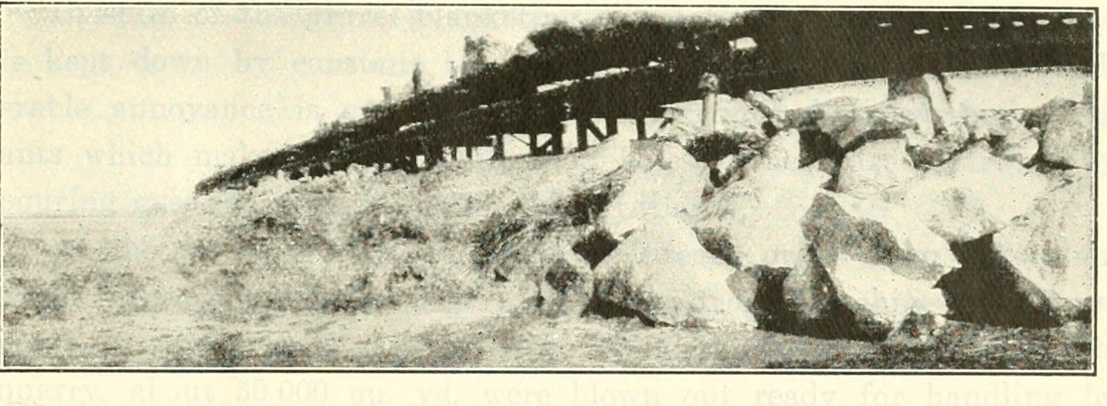
For about ten days almost no freight went out of San Pedro. Just before the closing the superintendent of the Los Angeles division telegraphed Cory asking for notice, as far ahead as possible, “when work will slow up because I want to make arrangements to resume operating the division.”
After
On 12 January 1907, with the second closing three weeks from done, Roosevelt sent Congress a message with the telegrams attached. “A cut in the river bank was made 4 miles farther south in Mexican territory. This gave the water a shorter and steeper course toward the valley. The making of this cut in a bank composed of light alluvial soil above a depression such as this without controlling devices was criminal negligence.” It asked for two million dollars for permanent works and a reclamation project to take the whole system over, and said that “the question as to what sum, if any, should be paid to the Southern Pacific Company for work done since the break of November 4, 1906, is one for future consideration; for work done prior to that date no claim can be admitted.” The bill passed the Senate. The valley’s own congressman opposed it in the House, at his constituents’ request: the farmers wanted the government’s help against the river and not its ownership of their water, and the Imperial Standard answered the message for them: “the people here know that the various departments of the government are primarily responsible for the conditions existing here.” The bill died.
The railway’s claim followed it. A bill to reimburse the Southern Pacific $1,663,136.40 went to the House Committee on Claims in 1908. Roosevelt wrote to the committee that the railway “by its prompt and effective work, rendered to a threatened community a notable service which could in no other way have been done.” Grunsky audited the accounts and found the net cost $1,083,673.97. The Secretary of the Interior, Newell and Walcott, asked by the President what was fair, found six beneficiaries, set the settlers aside, divided the rest five ways and suggested the United States might pay twenty per cent. Two years later a Senate bill cut the sum to $773,647.25 and passed; on 28 January 1911 five members of the House committee filed a minority report calling it “purely a gratuity, a gift of the people’s money to the Southern Pacific Railroad Company,” and the bill never came to a vote. Harriman had gone over the levees on a last trip through the valley in 1909, the year he died, and a reporter asked him whether, unpaid, he regretted the expenditure. “No,” Kennan reports him saying. “This valley was worth saving, wasn’t it?”
The company that made the cut did not survive it: the salt company took a judgment for $458,246.23 against it in November 1907, a receiver was appointed, and in time an irrigation district formed by the valley’s own water users took the works. Rockwood wrote his account in 1909 and ended it where this one began. “We have since been accused of gross negligence and criminal carelessness in making this cut,” he wrote, “but I doubt as to whether any one should be accused of negligence or carelessness in failing to foresee that which had never happened before.”
The river tested the work. The summer floods of 1907 and 1909 were larger than 1906’s, and the levees, rebuilt with muck ditches and a railway track on top, held; two years later the channel in front of the dam was so grown over with willows “that it was extremely difficult to believe that the break ever occurred there.” The Salton Sea reached its height in 1907, 197 feet below the sea, 76 feet deep, 445 square miles, fifty miles long. By 1912 it had fallen twenty-two feet, and Cory expected it to settle at eight or ten feet deep, kept by the valley’s drainage. The drainage grew with the valley, and the sea is there still.
What it taught
Start with what the cut was. It was not an accident and not a reckless act; it was a decision taken under a deadline, by a man who had run the works for years, from the only record there was, and it did exactly what it was designed to do. Water came into the valley that winter. The Alamo scoured. The thing that was not designed, because the company had no money for it and Mexico had not approved it, was the thing that would have told the river when to stop.
A record is not a law. Twenty-seven years of daily readings at Yuma said three winter floods and never two in one winter, and Rockwood read that as “not probable” and bet the valley on it. Five came. The record was true; it was simply short, and what it recorded was a river whose winter floods come from the Gila, which, as Cory wrote, “are far more to be feared and reckoned with, in preparing and conducting engineering work along the lower Colorado River, than anything coming down the Colorado River proper.” The hydrograph at the head of this entry shows what a longer sample looks like: 1905 is not the exception on it. Nobody who made the cut had seen that chart, because it did not yet exist, and the lesson is not that they should have. It is that the gate was the only thing in the design that did not depend on the river behaving as it had.
A safeguard that needs permission is not a safeguard yet. The plans for the controlling gate went to Mexico City in November 1904 and came back approved in December 1905, by which time the gate’s site was the bed of the river. In between, the company had a drawing, and the valley had a hole. An engineer’s intention to build a gate is worth exactly as much as the gate: nothing, until it is in. The same arithmetic ran the other way at the end. The levees of November 1906 were built without muck ditches because the railway’s money was for closing the break and not for the defence, and the river found the ninety places where the ditch was not, within a month.
The instrument was reading the wrong danger. Every reading the company took, from 1901 to 1904, said the river would not come in. Its whole engineering was a struggle “to induce enough water to go that way.” When the cut was made, the measure of success was water in the canal, and by that measure the cut succeeded through the winter. The measure that mattered was the width of the cut, sixty feet, then 160, then 600, then half a mile; it was in plain sight, and no one was charged with reading it, because the hypothesis had no place for it. Nine years later and two hundred miles west, the city of San Diego would own a dam that had never been full and hire a man to fill lakes, and read the staff gauge instead of the spillway (“Four Billion Gallons”). A system built by people who have only ever known too little will measure too little. Too much arrives unmeasured.
Fifty experts, no agreement, one method that nobody proposed. The men who finally held the river were not the men who argued about it. The rock fill was railway practice, done by “railroad men, who used methods with which they were familiar,” as Clarke wrote in the discussion of Cory’s paper, “they tried no experiments and devised no new engineering practice.” When the problem is without precedent, the plan that works is likely to be the one that can be done fastest with what is already in the yard, and the thing that proved the rock would hold was not a calculation but an exposed dam, examined dry after the gate had failed. The reading that settled the method was taken by accident.
Who pays for the test is decided after the result. Rockwood made the cut for a company with no money; the company was taken over by a railway that thought it was making a loan; the railway spent about three million dollars and never got a cent back; the valley subscribed $950,000 and never had to pay it; the government, whose land it was, whose dam at Laguna was saved, and whose President ordered the work “without an hour’s delay,” found five parties to share the cost and offered a fifth. Elwood Mead put it in the Society’s discussion: “the President, having Congress on his hands, shifted the responsibility to the head of a railroad company; and it was not until the railroad company took charge that we have the first refreshing example of generosity and public spirit.” The experiment had been run on public land, by a private company that nobody had the power to stop, and when it went wrong there was no one whose job it was to pay. That is what an unsupervised experiment on a commons looks like at the end.
Check the story before you learn from it. The cut is sixty feet wide in Rockwood’s account and forty or fifty in Newell’s and Grunsky’s; the first closing is 4 November in Cory and 6 November in Newell; the Thanksgiving flood is 116,000 second-feet in Cory and 102,000 or 115,000 in Kennan; the valley had 6,000 people, or 10,000, or 12,000. What does not move is the sequence: a cut without a gate in October, plans in a foreign capital in November, three floods in February, two dams swept in the spring, the whole river by August, and twenty-four days of rock in the autumn of the following year, after fifteen months of everything else. That is enough to learn from, and the man who undid the cut had drawn the lesson by 1913. “This real mistake,” Cory wrote, closing his account of the heading, “was not in ‘putting all the eggs in one basket,’ but in not ‘then watching that basket.’”
Sources
- H. T. Cory, “Irrigation and River Control in the Colorado River Delta,” Transactions of the American Society of Civil Engineers, vol. 76, paper 1270, December 1913, pp. 1204–1571, with the discussion by Elwood Mead, Francis L. Sellew, Andrew M. Chaffey, C. E. Grunsky, Clarence K. Clarke and others and the author’s closing. The company’s history, Rockwood’s statement, the five attempts, the gates, the summer flood of 1906, the preparations and the two closings, the second break, the levees, the claim, the damage and the Salton Sea; Plate XLVII and Figs. 46 and 55. archive.org
- H. T. Cory, The Imperial Valley and the Salton Sink, with an introduction by W. P. Blake, San Francisco, 1915: the same text reprinted as a book, paged as the Transactions. archive.org
- C. R. Rockwood, “Born of the Desert,” Calexico Chronicle, second annual magazine number, May 1909, as quoted at length by Cory (pp. 1286–1290) and by Kennan (pp. 36–39): Rockwood’s reasons for the cut, the plans sent to Mexico, the twenty-seven years, the five floods and the widening to 160 feet. Not seen in the original.
- Theodore Roosevelt, Imperial Valley or Salton Sink Region, message to Congress of 12 January 1907, Senate Document 212, 59th Congress, 2nd session, with Charles D. Walcott’s statement of 10 January 1907, the telegrams between E. H. Harriman and the President of 13 December 1906 to 7 January 1907, Walcott’s letter to Epes Randolph and Randolph’s replies, W. J. Doran’s statement of the company’s finances, the loan agreement of 20 June 1905 and the Mexican concession. archive.org
- C. E. Grunsky, “The Lower Colorado River and the Salton Basin,” presented 20 March 1907, Transactions of the American Society of Civil Engineers, vol. 59, paper 1051, December 1907, read in the Society’s Proceedings, vol. 33, 1907. The basin, the 1891 flood, the concession, the two Mexican headings without gates, 26 October 1904, the forty to fifty feet and the attempts of 1905. archive.org, Proceedings, archive.org, Transactions
- United States Reclamation Service, Fourth Annual Report, 1904–5, Washington, 1906, “Investigations in the Imperial Valley”: the Service’s survey of 1904, the 79,591 acres, the consideration of purchase, the measurement of 22 and 23 September 1905 and the twenty miles of submerged track. archive.org
- F. H. Newell, “The Salton Sea,” Annual Report of the Board of Regents of the Smithsonian Institution for 1907, Washington, 1908, pp. 331–345: “much against the advice of the engineers,” heading No. 3 at forty to fifty feet, the cutting of the channels, the rise of the sea by months from W. B. Clapp’s gauge, the closing of 6 November, and the description of the second closing. archive.org
- George Kennan, The Salton Sea: An Account of Harriman’s Fight with the Colorado River, New York, 1917. Written from Harriman’s papers; Randolph’s telegrams and Harriman’s “Go ahead and do it,” Grunsky’s “sufficiently alarming,” Cory’s testimony to the House committee, the claim’s history to 1911, Taft’s message and letter, and “This valley was worth saving, wasn’t it?” The quotations from Randolph, Harriman and Grunsky in this entry that are not in the Senate document or the Transactions are at second hand through Kennan. archive.org
- Edgar F. Howe and Wilbur Jay Hall, The Story of the First Decade in Imperial Valley, California, Imperial, 1910: Rockwood’s arrival, the cut at fifty feet, the dates of the five rises of 1905, Perry’s attempt, and the fight at the Calexico levee in April 1906. archive.org
- L. M. Holt, compiler, The Unfriendly Attitude of the United States Government towards the Imperial Valley, Imperial Daily Standard, April 1907, with the Standard’s editorial of 8 February 1907. archive.org
- Alfred J. Henry, “The Salton Sea and the Rainfall of the Southwest,” Monthly Weather Review, December 1906, as quoted by Cory (pp. 1415–1416).
- H.R. 18907, 60th Congress, 1st session; S. 417, 61st Congress; House Report 1936, 61st Congress, 3rd session, with its minority report of 28 January 1911: the claim, as quoted by Cory (pp. 1402–1406) and Kennan (pp. 93–104). Not seen in the original.
How this entry came about
Written in the overnight run of 22 October 2026 under the standing rules in _ideas/OVERNIGHT.md, with nobody to ask; each decision below was taken under those rules and recorded here. The backlog line named Cory's paper, the Reclamation Service's reports and Roosevelt's message. All three were read in full on archive.org, Cory's in the Transactions of 1913 and in the 1915 book, with its discussion; the Senate document of January 1907 with its telegrams and exhibits; the Reclamation Service's Fourth Annual Report; and beside them Grunsky's paper of 1907, Newell's Smithsonian article, Kennan's book of 1917 written from Harriman's papers, the valley's own history of 1910 and Holt's pamphlet of 1907.
Sources not reached, and what stood in. The Imperial Valley Press, the Los Angeles Herald and the San Francisco Call of 1905 to 1907 are in Chronicling America, and loc.gov's search answered once (it found the Imperial Valley Press of 22 December 1906 and the Herald of 11 December 1906), but its word-coordinates text service answered 520 on every attempt through the night, so no newspaper page was read and none is cited. Rockwood's "Born of the Desert" (Calexico Chronicle, May 1909) is not online and is quoted as Cory and Kennan print it, which agree. The Congressional bills, hearings and House Report 1936 are not on archive.org and are given as Cory and Kennan quote them. Grunsky's report of June 1905 for the Reclamation Service was not found in the Fourth Annual Report's text; "not serious, but sufficiently alarming to require some attention" is Kennan's quotation of it, used in the companion. Harriman's exchange with Randolph ("Go ahead and do it") and his words to the Los Angeles Examiner's reporter are Kennan's, from Harriman's papers, at second hand. The scan of Transactions vol. 59 on archive.org drops short words from every line, so Grunsky was read in the Proceedings of 1907, whose text is clean. The Sixth Annual Report of the Reclamation Service (1906–07) was downloaded and has no account of the break.
Numbers and dates that differ. The width of the cut: "about 60 ft." (Rockwood, in Cory and Kennan), "40 to 50 feet wide and 6 to 8 feet deep" (Newell, Grunsky), "50 feet wide... and 6 or 8 feet deep" (Howe and Hall); the entry uses Rockwood's for the title and gives the others. The date of the first closing: 4 November 1906 (Cory, Table 13 and text; Roosevelt's message) or 6 November (Walcott's letter of 28 December 1906; Newell). The Thanksgiving flood of 29 to 30 November 1905: 31.8 feet and 116,000 second-feet (Cory), 102,000 and 115,000 (Kennan, on different pages), "more than 100,000" (Grunsky). The rise of the sea in June 1906: 16.4 feet (Cory) or 15.4 (Clapp's table in Newell). The bottom of the sink: 278 feet below sea level (Grunsky), 287 (Reclamation Service, 1905), "about 300" (Newell). The population: 6,000 to 10,000 (Roosevelt), 10,000 (Holt, in Grunsky; Cory's 2,500 in towns and three times that in the country), 12,000 (Kennan). Acreage: 79,591 irrigated in March and April 1905 (the Service), "over 100,000" (Roosevelt), "at least 125,000 under cultivation" (Cory). The Mexican approval of the gate plans: "the month of December, 1905" in the Transactions and in Kennan; the Google scan of the 1915 book reads "1906," an OCR error; Grunsky says the canal plans were approved on 28 August 1905. The rock in the first closing: 1,690 cars and 50,000 cubic yards (Table 13, read from the page image; the OCR gives 1,600 and 80,000). The materials after the second break: 1,517 battleships, 1,240 flat cars, 956 of clay and 1,052 of gravel in Cory, 4,765 in all; Kennan gives 5,765. Cory's text gives the land ruined in 1906 as 8,000 improved and 10,000 unimproved acres on p. 1324 and 3,000 cultivated and 10,000 uncultivated on p. 1409, and Districts 6 and 8 as waterless until January 1908 on p. 1324 and January 1907 on p. 1409; the entry and the companion say about 30,000 acres lost their water and do not choose. The Calexico levee is a mile long in Howe and Hall and about five miles round both towns in Cory. Cory's paper puts Patagonia 370 miles from Hanlon's Junction; his testimony as Kennan quotes it says 485. The Gila flood of December 1906 "came down" on 5 December by Cory's text and reached the heading on the night of the 7th, which is the date everyone gives the break. Cory's age in April 1906 is given as thirty-five from his birth year of 1870 in the archive.org catalogue record of the 1915 book.
Decisions under the rules. Three figures, all from Cory's paper in the Transactions of 1913, a publication before 1930 (rule 1): Plate XLVII, the hydrograph, cut from the 400 dpi scan of Northeastern University's copy at 3,250 pixels and reduced to 1,600; Fig. 46, the Rockwood gate, which carries the photographer's copyright line of 1906 in the halftone and is credited to him; Fig. 55, the second closing. Nothing upscaled. Newell's plates (Reclamation Service photographs) and Grunsky's were not used because the Transactions halftones are the better scan; Kennan's photographs were left out as unattributed. A first draft of 9,842 words by the checker's count was cut in three passes to the house length, and the valley's year under water, the exchange of telegrams with the history of the claim, and the engineering of the two closings with Cory's tables were moved into four companions under 3,000 words each (rule 2). The quotations at second hand are listed above and in Sources (rule 3). The date was set at the push by rule 4 and the companions carry it. The title is Rockwood's own figure for the cut and is not used in _posts (rule 5). No pull request (rule 6). Where Cory's OCR was doubtful ("15 days and 5 hours" on p. 1376) the entry follows the legible figures and Kennan's "fifteen days." The entry does not say who died in each closing, because Cory does not name them. The date was set as 02:00 on 22 October at the push, the current UTC hour rounded down, 00:00 and 01:00 being held by the two entries before it (rule 4).
Narration. The six files were rendered by render-many.sh two at a time, from 02:01 to 02:18 UTC, after the writer ahead's six renders had ended; the gate was left at its default and held each launcher for a minute or two while the one-minute load from other accounts' processes stood between 26 and 42 (once at 331), and opened on its own each time, so no override was used (rule 10). Every log ends exit 0. The younger version came out of the checker at 2,818 words after its first render, eighteen over rule 2's 2,800, so it was trimmed by about thirty words, rendered again with FORCE=1, uploaded and wired again before the landing. Forty respellings went into say-as/sixty-feet.txt: the names the voice got wrong (Gila as "Heela", Heber, Schuyler as "Skyler", Patagonia, Andrade, Evarts, Tucson, Algodones, Carrillo, Diegueños, Eulogio, Papagoes, Silas, Encina, rurales, Cocopahs), "Co." as "Company" and "No." as "Number" in the quotations, and the abbreviated units and spaced figures in Cory's quotations ("60 ft.", "2 400 ft.", "$250 000", "6 600 cu. yd.") written out, each with its own number so that the pattern cannot catch another word. One figure in a quotation in "The telegrams" was given its comma before rendering and committed.